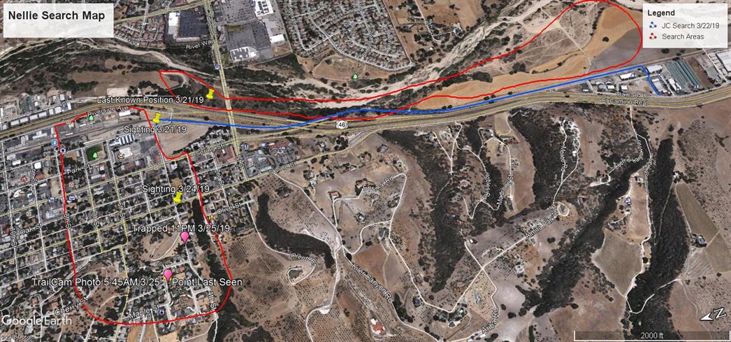
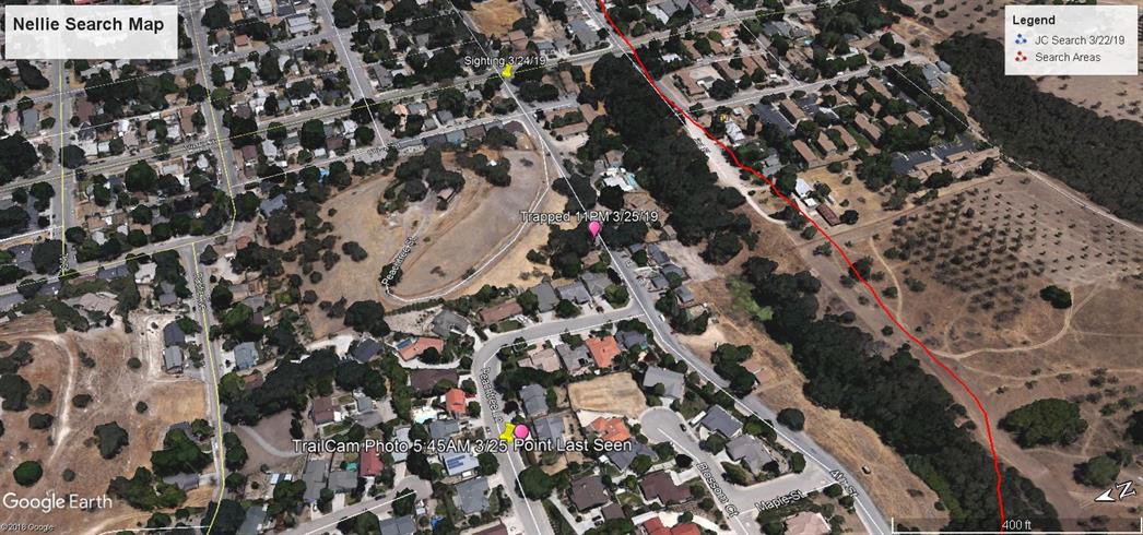
Strategic Pet Recovery
Strategy - Technique - Tools
Field Proven Skills to Recover Lost Pets
“Pets have more love and compassion in them than most humans."   Robert Wagner

Technique: Comprehensive Mapping - covering completely or broadly


Maps

Maps are a universal medium for communication, easily understood and appreciated by most people, regardless of language or culture (Merriam 1996).

For our purposes, Comprehensive Mapping means complete; including nearly all elements or aspects of something. This is exactly what we need in order to find and ultimately recover a lost pet.  Using a map gives us a single place to collect and view all information from what we have learned and accumulated each day until the recovery is complete. In doing so, the map will reveal clues about who to contact, what to do next, when and where to search, and why.

There are only a few elements of a map we really need to understand., which include scale, legend, symbols, waypoints, contour lines and how to orient the map.  Of course learning more about using a map is a useful skill to possess, but it may not create a significant advantage over basic skills to find a lost pet. This is because our primary use of a map is to add data,  which we will refer to as Points of Interest (POI), as described  in the Conduct a Search section.  Every POI on the map helps our decision making about finding a lost pet with  "spatial analysis" . Using a map for this type of decision making is much stronger as compared to simply writing down a list of POI's on a piece of paper because our brain will process the information more effectively when layered over a map showing terrain, roads and other data.

"Whenever we look at a map, we inherently start turning that map into information by analyzing its contents, finding patterns, assessing trends, or making decisions. This process is called “spatial analysis,” and it's what our eyes and minds do naturally whenever we look at a map. Spatial analysis allows you to solve complex location-oriented problems and better understand where and what is occurring in your world. It goes beyond mere mapping to let you study the characteristics of places and the relationships between them. Spatial analysis lends new perspectives to your decision-making."  [credit: ArcGIS Blog]


Media

Maps are used on various forms of media. The most poplar today are electronic maps on cell phones, tablets, desktop computers and GPS devices. Paper maps work just as well for our purposes but do not have the enhanced tools found using online maps. If necessary,  a map can be made from a single piece of blank paper indicating the various points of interest and other collected information about search effort shown on a relative scale.

Two of the most easy, effective and free tools available are Google Maps (GM)  and Google Earth (GE). They both work okay on a cell phone, better on a tablet, and best on a desktop PC.  A GPS unit, which could be your cell phone, works separately if desired to collect waypoints and POI location information.

There are many other mapping apps and software available, so use what you prefer and is easy for you. The last thing you want to deal with are complications from a mapping program (hence if paper works best for you, use it). 

How To Create a Custom Map With Google "My Maps"
Google My Maps is Different than the standard Google maps app

Most people are aware of Google Maps, which is commonly used. Yet most are not aware that you can make, save and share custom maps when you're logged into a Google account.  Google My Maps runs on both Android and iPhone cell phones and tablets.

Android Instructions for Creating a Custom Map

iPhone Instructions for Creating  a Custom Map

For desktop PC's, simply log into your Google account to create custom maps.

Desktop PC Instructions for Creating a Custom Map


Be sure to use and familiarize yourself with the app/program before actually needing to use it.  Google has lots of online help, thus I have not repeated it here.

What to Put On Your Map

You map is a collection of a anything and everything observed, heard, reported, considered, thought about or indicated that supports locating and recovering a lost pet.  All of these and more are referred to as Points Of Interest (POI) as described on the Conduct a Search page. When you learn of a new POI is is imperative that you note the related location right away so it can be added to your map later. Do not rely on your memory.  Using Latitude and Longitude is good, but not necessary given you can locate and mark the POI properly using you map tools (some more advanced techniques involve using a GPS in the field to mark a waypoint for every POI, then upload the waypoints at the end of the day to the custom map).

With POI's in mind, lets look at a a couple of maps using Google Earth to see how the correlate to a search and recovery of a lost dog.

Map Example 1

Map example 1, above,  shows only the fundamental elements of a search and recovery.  Most of the POI's are removed to illustrate the basic concept of using a map to make choices about locating a missing dog.  In this case, the dog was missing far away from home and thus his behavior would be too seek shelter, food and water.

In the upper right is a map key showing the first through fifth sighting of the dog over a six week period. Each of these points of interest is shown on the map (1 - 5).  In the lower left you can see the Point Last Seen (PLS) and in the lower right you can see the Last Known Position (LKP).  Sightings 1 through 4 were developed through contacting people in the field and interviewing them. Sighting 5 was developed through social media interaction.

The red line indicates the dogs approximate path of travel based on time and location of the sightings. The yellow lines indicate where the dog left obvious tracks in the dirt.

Analyzing the information resulted in a conclusion that the dog would likely return to the landfill. The dog was only observed once at locations 2, 3, and 4 but had returned to the same area he was first observed.  Upon inspection, dog prints were found in multiple locations within the landfill. Contacting employees at the landfill verified multiple sightings in the same general area.  To verify the conclusion, a trail camera was placed within the landfill property next to a bowl of water and a dish of dog kibble. The camera caught the dog later the same evening and was ultimately trapped the following day.

Map Example 2

Map example 2, above, shows points of interest for a dog that went missing in remote rural and wilderness areas, also very far from home.  Many people were contacted face to face and multiple points of interests were developed when searching the large area. The combination of the Strategy actions and analyzing the data on a map led to a reduced search area.

Map Example 3

Map example 3, above, shows the reduced search area. The red line shows the dogs approximate path of travel and the blue circle shows the smaller search area.  You can see the three repeat sightings in the area. The dog was ultimately recovered within this area.

 
Map Example 4


In map example 4, above, a dog went missing in an urban/ residential  area which is adjacent to a rural environment. The red lines show two separate search areas, one being in an urban neighborhood and the other being in a rural area along a river. There were two sightings when the dog first went missing followed by two days of no sightings at all.
The search of the river bed area yielded no points of interests whatsoever, no tracks, no sightings, no useful information from people contacted, nothing.

The search area in the urban neighborhood is where the dog went missing. The dog was not familiar with the area, so initially equal odds could be given to locating the dog in either of the two search areas.  While we might believe the dog could be in the rural search area because that was her last known direction of travel, we can see from our map that there are no points of interest developed after two full days of searching this area.

Map Example 5


In map example 5, above, we have a point of interest showing a single and verified sighting about six blocks from where the dog went missing three days earlier.  This single sighting is enough to show the dog is returning to the Point Last Seen, even though it was not a place she was familiar with (a common behavior for dogs).  In addition to a foot search, a trail camera was placed at the Point Last Seen. The dog showed herself on camera early the next morning.  An evaluation of the area, using a map and a verified by foot search (i.e. dog tracks in the field), strongly suggested that the dog was using a nearby vacant piece of property for shelter. A trap was placed and the dog was recovered.

The examples shown in maps 4 and 5 provide two strong lessons; 1) if no points of interest are developed during a foot search of a given area, odds are the dog is not in that area, and 2) a single verified sighting can be enough to determine the dogs whereabouts when coupled with a foot search for other evidence.

Other Data

There are sources of fixed and dynamic data that you may choose to add to your map based on the circumstances of your search efforts. Google Earth, for example, has a long list of data available such as weather, buildings, water outlines, park boundaries and so on. Elsewhere online you'll find KMZ files which may relate to your search area and can be imported into your map. Lastly, other data sources may prove useful if you're attempting to solve issues which very uniquely are preventing progress to your search.  These may include anything from police dispatch logs (often found online) which include location information, cell phone coverage maps from phone provider websites, to traffic information found online. While these data sources may seem odd at the moment, they serve as a reminder to think about what data, if made available, would aide in your search to find a lost (or possible stolen) pet. Sometimes the answer may surprise you.